
Fire Towers of New Hampshire

| MAP PACK NH Fire Towers Download · Instructions |
We've explored every fire tower in New Hampshire, mapped the trails on which to reach them and published trail reviews to help you plan your next outdoor adventure. Now we've gone a step further with our Map Pack - providing a single smartphone download containing trail reviews and route navigation information. Map Packs are free for personal use and even work when you're offline.
See these links for fire towers in other areas:
Beyond this map you can see our individual trail reviews. These trail reviews included photograph and even more detailed maps leading to the fire towers and other points of interest along the route.
❤️ Best for families
🚗 Reach without a hiking trail
🏆 Fire Tower Quest (?)
Trail Reviews
5-Star Trails
 Cardigan Mountain 5★ 🏆
3-5 mi · Moderate ·
Sunapee Region


4-Star Trails


3-Star Trails


How High Can I Go?
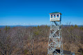
Many fire towers are safe to climb, and some also have an accessible cabin for the best views. It's even possible to spend the night in a few of them - no reservation required. Please respect any locked gates, posted signs and do not climb any fire tower that may be unsafe.Even when fire tower cabins are locked, all of the towers can be climbed to a platform immediately below the cabin where there are still great views. The only ones that can't be climbed are Cardigan, Craney, Deer (unsafe/no cabin) and Kearsarge.
Many fire tower cabins are usually locked, but may open from time-to-time. Cabins known to open routinely at weekends from (approximately) May to September are Belknap, Blue Job, Pawtuckaway and Prospect - particularly at times of moderate to high fire danger. Cabins known to always be open are Kearsarge North, Smarts and Stratham; and people are even known to sleep in them. We recommend checking our trail reviews and the official websites we link to for additional details.
Other Towers
There are some other towers not listed here. They are the remote towers of Whitcomb, Signal and Carrigain which are difficult to reach. We may add them to the map at a future time once we've validated a safe route to reach them. Croydon Fire tower is excluded from the list because it's on private land occupied by an exclusive hunting reserve. There are also towers in the state that are excluded from our map because they have never been active fire towers, including the Abenaki Tower in Tuftonboro and Garrison Hill Tower in Dover.
New England Covered Bridges
Maps, lists, directions and nearby trails to New England's covered bridges.
Maps, lists, directions and nearby trails to New England's covered bridges.

New England Rail Trails
The first and only complete rail trail map. Photos, reviews and downloads.
The first and only complete rail trail map. Photos, reviews and downloads.

New England Summits
Explore mountain-top hikes around New England with Trailspotting.
Explore mountain-top hikes around New England with Trailspotting.