Posts
Showing posts with the label 7-10miles
Goathland to Grosmont, North Yorkshire UK
• 4-star hikes
• 3 to 8 mile options
• Easy/Medium difficulty | Gain 310 to 1,200 feet
• North York Moors, UK | North Yorkshire
…
• 3 to 8 mile options
• Easy/Medium difficulty | Gain 310 to 1,200 feet
• North York Moors, UK | North Yorkshire
…
Hayeswater Loops, Cumbria UK
• 5-star hikes
• 6 to 12 mile options
• Medium difficulty | Gain 2,730 to 4,190 feet
• Lake District National Park | United Kingdom
…
• 6 to 12 mile options
• Medium difficulty | Gain 2,730 to 4,190 feet
• Lake District National Park | United Kingdom
…
Scafell Pike, Cumbria UK
• 5-star hikes
• 5 to 11 mile options
• Medium difficulty | Gain 2,920 to 4,110 feet
• Lake District National Park | United Kingdom
…
• 5 to 11 mile options
• Medium difficulty | Gain 2,920 to 4,110 feet
• Lake District National Park | United Kingdom
…
Blakey Topping, North Yorkshire UK
• 4-star hikes
• 3 to 10 mile options
• Medium difficulty | Gain 520 to 1,750 feet
• North York Moors, UK | North Yorkshire
…
• 3 to 10 mile options
• Medium difficulty | Gain 520 to 1,750 feet
• North York Moors, UK | North Yorkshire
…
Bridestones, North Yorkshire UK
• 4-star hikes
• 1 to 10 mile options
• Medium difficulty | Gain 250 to 1,750 feet
• North York Moors, UK | North Yorkshire
…
• 1 to 10 mile options
• Medium difficulty | Gain 250 to 1,750 feet
• North York Moors, UK | North Yorkshire
…
Pulpit Rock & Joppa Hill, Bedford NH
• 3-star hike
• 2 to 9 mile options
• Medium difficulty | Gain 230 to 740 feet
• Bedford, NH | Merrimack Region
…
• 2 to 9 mile options
• Medium difficulty | Gain 230 to 740 feet
• Bedford, NH | Merrimack Region
…
Iron Mountain, Poway CA
• 4-star hike
• 5.6 to 8.6 mile options
• Medium difficulty | Gain 1,110 to 1,950 feet
• Poway, CA | San Diego Region
…
• 5.6 to 8.6 mile options
• Medium difficulty | Gain 1,110 to 1,950 feet
• Poway, CA | San Diego Region
…
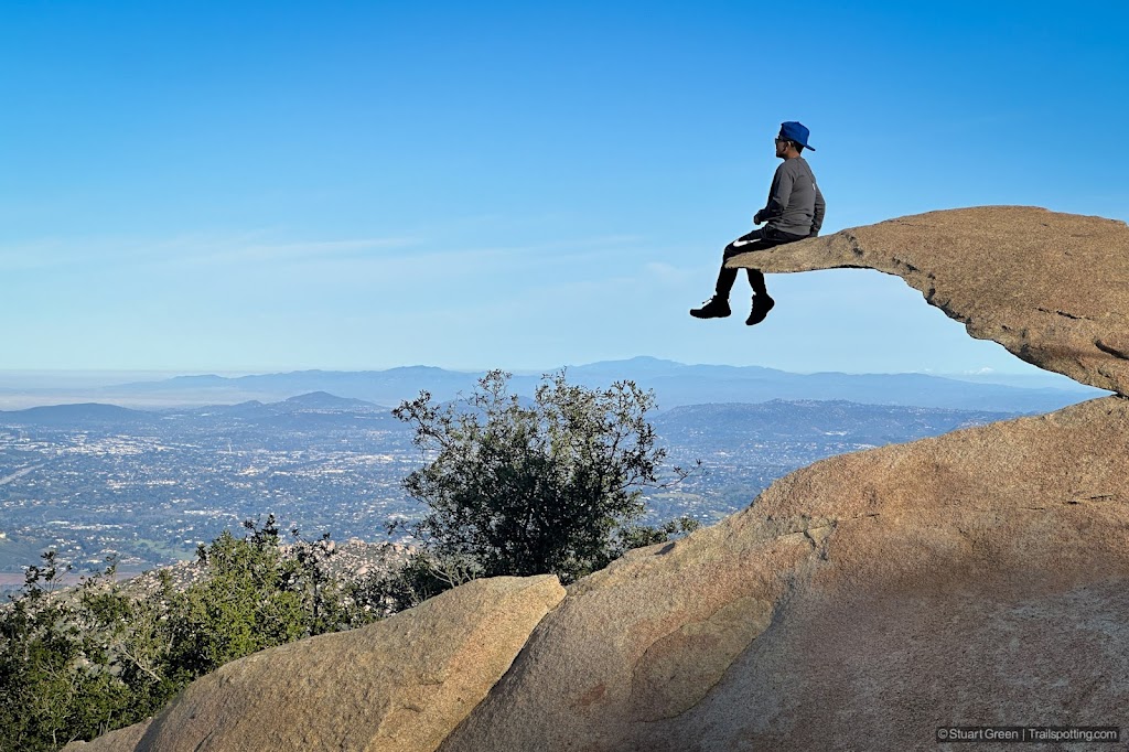
Potato Chip Rock & Mt Woodson, CA
• 5-star hikes
• 4 to 8 mile options
• Medium difficulty | Gain 1,220 to 2,170 feet
• Poway, CA | San Diego Region
…
• 4 to 8 mile options
• Medium difficulty | Gain 1,220 to 2,170 feet
• Poway, CA | San Diego Region
…
Mt Moosilauke, White Mountains NH
• 5-star hike
• 7.4 to 7.9 mile options
• Medium difficulty | Gain 2,470 to 2,570 feet
• Benton, NH | White Mountains
…
• 7.4 to 7.9 mile options
• Medium difficulty | Gain 2,470 to 2,570 feet
• Benton, NH | White Mountains
…
Sandwich Mt & Jennings Peak, NH
• 4-star hike
• 6.1 to 8.0 mile options
• Medium difficulty | Gain 2,080 to 2,740 feet
• Waterville Valley, NH | White Mountains
…
• 6.1 to 8.0 mile options
• Medium difficulty | Gain 2,080 to 2,740 feet
• Waterville Valley, NH | White Mountains
…
North Central Pathway Rail Trail, MA
• 4-star trail
• 9.5 miles each way
• Easy difficulty | Easy elevation
• Winchendon to Gardner, MA | Central Massachusetts
…
• 9.5 miles each way
• Easy difficulty | Easy elevation
• Winchendon to Gardner, MA | Central Massachusetts
…
Upper Coos Rail Trail, NH
• 4-star trail
• 9.5 miles each way
• Medium difficulty | Easy elevation
• Colebrook NH - Beecher Falls VT | Great North Woods
…
• 9.5 miles each way
• Medium difficulty | Easy elevation
• Colebrook NH - Beecher Falls VT | Great North Woods
…
Old Colony Rail Trail, Cape Cod MA
• 4-star trail
• 7.5 miles each way
• Easy difficulty | Easy-moderate elevation
• Harwich to Chatham, MA | Cape Cod
…
• 7.5 miles each way
• Easy difficulty | Easy-moderate elevation
• Harwich to Chatham, MA | Cape Cod
…
Pack & North Pack Monadnock, NH
• 3 & 4-star hikes
• 2.7 to 7.7 mile options
• Medium difficulty | Gain 810 to 1360 ft
• Greenfield & Peterborough, NH | Monadnock Region
…
• 2.7 to 7.7 mile options
• Medium difficulty | Gain 810 to 1360 ft
• Greenfield & Peterborough, NH | Monadnock Region
…
Mt Roberts & Faraway Mountain, NH
• 3 & 4-star hikes
• 2.4 to 9.7 mile options
• Medium difficulty | Gain 420 to 1,650 feet
• Moultonborough, NH | Lakes Region
…
• 2.4 to 9.7 mile options
• Medium difficulty | Gain 420 to 1,650 feet
• Moultonborough, NH | Lakes Region
…
Goffstown & Piscataquog Rail Trails, NH
• 4-star trail
• 7.5 miles each way
• Easy difficulty | Easy elevation
• Goffstown - Manchester, NH | Merrimack Region
…
• 7.5 miles each way
• Easy difficulty | Easy elevation
• Goffstown - Manchester, NH | Merrimack Region
…
Middleton Rail Trails, MA
• 3 & 4-star trails
• 2.2 to 7.5 miles each way
• Easy/Hard difficulty | Easy elevation
• Middleton to Danvers, MA | NE Massachusetts
…
• 2.2 to 7.5 miles each way
• Easy/Hard difficulty | Easy elevation
• Middleton to Danvers, MA | NE Massachusetts
…
Boxford-Georgetown-Byfield Rail Trails, MA
• 3-star trails
• 8.3 miles each way
• Easy/Medium difficulty | Easy elevation
• Boxford-Georgetown-Byfield, MA | NE Massachusetts
…
• 8.3 miles each way
• Easy/Medium difficulty | Easy elevation
• Boxford-Georgetown-Byfield, MA | NE Massachusetts
…
Minuteman Bikeway Rail Trail, MA
• 4-star trail
• 10.0 miles each way
• Easy difficulty | Easy-moderate elevation
• Bedford to Arlington, MA | NE Massachusetts
…
• 10.0 miles each way
• Easy difficulty | Easy-moderate elevation
• Bedford to Arlington, MA | NE Massachusetts
…
Bedford and Concord Rail Trails, MA
• 4-star trails
• 7.5 miles each way
• Easy difficulty | Easy elevation
• Bedford & Concord, MA | NE Massachusetts
…
• 7.5 miles each way
• Easy difficulty | Easy elevation
• Bedford & Concord, MA | NE Massachusetts
…
Trailspotting is non-commercial, ad-free and for the public good.
Content provided without warranty of accuracy. Copyright © 2005-2024 Stuart Green all rights reserved. Reproduction requires explicit consent.
About Trailspotting .
Content provided without warranty of accuracy. Copyright © 2005-2024 Stuart Green all rights reserved. Reproduction requires explicit consent.