Rockingham Portsmouth Branch RT, NH
• 4-star trail
• 28 miles each way
• Easy | Low gradient
• Manchester-Rockingham, NH | Merrimack, Seacoast Regions
.

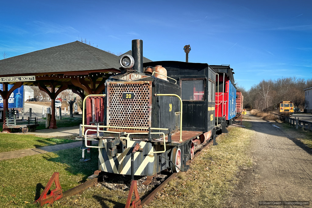
Historic rolling stock on parade at former Raymond Station
Constructed by the Portsmouth and Concord Railroad company and serving the region's towns for over 130 years, the route is now known as a very popular rail trail called the Portsmouth Branch of the Rockingham Recreational Rail Trail. At 28 miles in length it also ranks as the second longest in the state after the Northern Rail Trail.
This predominantly smooth and level hardpack trail links downtown Manchester to the former railroad station of Rockingham, merely a couple of miles south of Newmarket. Originally, twelve passenger depots were originally situated on this line though only two remain today. You can see the locations of these former stations by turning on markers inside our map. The town of Raymond have not only refurbished their station and use it to house the Raymond Historical Society's collection, but also proudly showcases a refurbished steam locomotive and several historical rail cars adjacent to the rail trail.
| ⬤ 4★ Rockingham Recreational Rail Trail
GPX File · AllTrails · Directions GPX? |
| P Free parking |
Towards the eastern end of lies Rockingham Station, currently undergoing a gradual restoration owing to the efforts of the local landowner. Here the end of the trail meets up with live rail tracks. In addition to the presence of a north-south rail line, a section of the Portsmouth and Concord Railroad remains in service from this point, leading into Portsmouth and its nearby Naval Shipyards. Additionally branching off this railroad route some 8 miles eastward marks the start of the Seacoast Greenway Rail Trail.
Further features along the mostly wooded Rockingham Rail Trail Portsmouth Branch include wetlands and several lakes, including Manchester's popular Massabesic Lake that has a spacious parking area - a great starting point for a rail trail adventure. Near Raymond, the rail trail crosses Lamprey River twice over a couple of well-preserved steel girder bridges. Less scenic but also necessary are the two dark corrugated culvert-style underpasses that stretch under large highways and will likely require you to dismount due to low headroom.

Exiting one of the low-headroom culvert-style underpasses
The 18 mile long Fremont Branch rail trail connects directly with this trail at Epping and runs southwest until it connects with several other trails at the Windham Station Junction, including direct connections to Derry and Windham rail trails, along with a short road connection to link to the Windham Greenway Rail Trail. We've linked to our separate reviews of these trails at the bottom of the article.
Manchester serves as a hub for multiple additional rail trail connections, including the Piscataquog-Goffstown Rail Trails (leading to the New Boston Rail Trail) and the recently extended South Manchester Rail Trail (leading to the Londonderry Rail Trail). At the foot of this page there are links to reviews and maps for these rail trails, and there's always our map of New Hampshire rail trails if you're looking to visualize all the possible connections and bicycle touring options.
⚠ Trail Conditions: Hardpack surface, very occasional protruding stones. Mostly negligible gradient. East Candia has a modest 25ft/mi gradient for 5 miles sloping upward to the West. Flooding possible at Rockingham after heavy rains.

Riding past Wetlands near Rockingham.

One of two steel girder bridges over the Lamprey River near Raymond.

Manchester's vast Lake Massabesic.

Rail trail cyclists on a winter morning.
Tangents:
• Official: NH State Parks
• AllTrails Public: Rockingham Portsmouth Branch
• TrailLink: Rockingham Portsmouth Branch
• Facebook Group: Comment, Follow Us

Trailspotting Nearby
3★ South Manchester Rail Trail (2 mi) ·
4★ Derry & Windham Rail Trails (8 mi) ·
Show Map

Rail Trails of New England
The first and only complete rail trail map. With photos, reviews and downloads.
The first and only complete rail trail map. With photos, reviews and downloads.

New Hampshire Lake Trails
Find trails that feature lakes along their journey.
Find trails that feature lakes along their journey.


