Fisherman's Walk & Cliff Walk, York ME
• 4-star hikes
• 1 to 2 mile options
• Easy | No elevation gain
• York, ME | Maine
.

Wiggly Bridge at Barrell's Millpond.
These two pleasant and easy coastal trails are a great choice when you're in search of cooler ocean breezes and the scent of sea air. Located only five miles outside of New Hampshire's Northern border, we hiked these trails in combination with an exploration of the pretty town of York, Maine.
We describe these two trails below. Be aware that parking can be a challenge in York as there are no parking lots. Many established parking spots, including those at the Harbor Beach loop, are reserved for residents only. We found many two hour spots available for our use along York Street, but longer duration parking requires some exploration and a little extra walking. For convenience we've marked a possible roadside parking location on our map that should allow for more than two hours, but please check for signs and notices as unfortunately we can't be responsible for your parking ticket.
| ⬤ 4★ Fisherman's Walk and Wiggly Bridge
GPX File · AllTrails · Directions GPX? |
| ⬤ 4★ York Harbor Cliff Walk
GPX File · AllTrails · Directions |
| P Limited free 2hr parking |
⬤ Fisherman's Walk & Wiggly Bridge
Like the Cliff Walk, this trail begins close to Harbor Beach, before heading inland by following the banks of the York River. First settled by Europeans in 1624, the town that was to become York developed a prosperous seaport. There's little sign of any such activity today, but the harbor inlet is still busy with pleasure craft and seafront restaurants.
Beyond the crosswalk on Route 103 you'll find the Barrell's Millpond dam. Constructed in 1727 to hold back Meeting House Creek and create power for new grist and sawmills at its Southern end. The current version of the dam is the result of a 1922 restoration, and leads across the scenic 1930s suspension bridge colloquially known as Wiggly Bridge. Beyond the bridge is the small nature preserve known as Steedman's Woods. Consider a looping stroll around the woods before heading back from where you came, or like we did, consider a longer walk to the center of town for lunch or to find the ice cream shop.

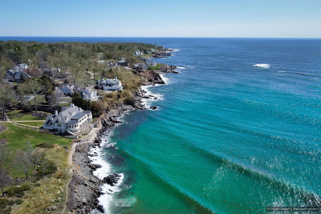
York Harbor Cliff Walk from above.
⬤ York Harbor Cliff Walk
From the sandy Harbor Beach, this half mile of narrow trail leads you over rocky shoreline between million dollar homes and million dollar views. Beginning with soil underfoot, becoming occasionally rocky and then becoming a concrete path, you'll have to contend with some occasional uneven rocky patches but these will not trouble most people.
These cliffs don't have much height to them - you remain close to the ocean for the full length of this trail, but distant enough not to worry about getting wet. The trail terminates at a small pleasant pebbly beach in front of the gardens of a seafront home. Please keep to the mapped trail to avoid trespassing on anyone's property, and respect your neighbors by leaving things like bluetooth speakers at home. No dogs are allowed on the Cliff Walk.

A narrow section of Cliff Walk towards trail's end.
Tangents:
• Trail Links: Barrells Mill Pond History (PDF)
• AllTrails Public: Cliff Walk, Fisherman's Walk
• Facebook Group: Comment, Follow Us

Trailspotting Nearby
4★ Ogunquit Marginal Way (1 mi) ·
4★ Mt Agamenticus (1-2 mi) ·
3★ Portsmouth Little Harbor (2 mi) ·
Show Map

New England Covered Bridges
Maps, lists, directions and nearby trails to New England's covered bridges.
Maps, lists, directions and nearby trails to New England's covered bridges.

New England Fire Towers
Discover our map of fire towers and the trails to find them.
Discover our map of fire towers and the trails to find them.
