
Mount Diablo, Contra Costa CA
• 4-star hikes
• 8 to 11 mile options
• Moderate & Hard | Gain 2,280 to 3,390 feet
• Clayton, CA | San Francisco Region
.

The Mount Diablo Summit Museum on the mountain's peak.
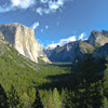
The morning fog blankets the valley below as we ascend, leaving behind the shrouded cities and emerging into brilliant sunshine. This phenomenon perfectly illustrates exactly why Mount Diablo remains a popular destination for Bay Area hikers seeking clarity above the clouds. As the tallest peak visible from San Francisco when low clouds settle over the bay, Mount Diablo offers a reliable escape to sunshine and panoramic views.
The Visitor Center and Museum at Mount Diablo's summit offer refreshments including drinks and ice creams for all visitors, whether they choose to drive to the summit or arrive on foot. The building itself encloses the true summit of Mount Diablo, so be sure to visit the interior if you want to stand on the mountain's highest point.
| ⬤
4★ From Rock City
GPX File · AllTrails · Directions GPX? |
| ⬤
4★ From Sunset Trailhead
GPX File · AllTrails · Directions |
| ⬤
4★ Mt Diablo & North Peak from Rock City
GPX File · AllTrails · Directions |
| $ CA State Park fee |
We particularly like this trail in spring, when wildflowers are in full bloom and the weather is temperate. The East Bay's characteristic golden hills transform with patches of purple lupine, orange poppies, and yellow buttercups during this season. As with many East Bay hikes, this trail is best avoided during peak summer temperatures, when the exposed route can become uncomfortably hot.
⬤ From Rock City
The Summit Trail from Rock City starts near the Mount Diablo State Park Boundary at around 1,600 feet of elevation. The trail begins as a service road, eventually becoming a narrow single-track as it gets closer to the summit, but surface conditions remain easy throughout. A modest gradient spread over several miles makes the climb feel moderate at worst.
⬤ From Sunset Trailhead
For those looking for a shorter hike, drive further up Summit Road to the Sunset Trailhead, where you may find a parking spot you could start your hike of the Summit Trail from a higher elevation. Although this shortens the Summit Trail, you still benefit from its best features.

Heading up on the fire road, with little shade.
⬤ Mt Diablo & North Peak from Rock City
Upon sighting the impressive mass of North Peak from the summit of Mount Diablo we decided we had to add it to our hike, and we're glad we did. Our spring hike from the Devil's Elbow trailhead towards North Peak was where we found the best displays of wildflowers by far. Note that the final part of the ascent on North Peak Road is rather steep - we found it harder to come down than go up - so we've categorized this as hard. We recommend high-friction footwear that you trust and a little patience, if you want to hike this peak.
If you would like to hike the trail to North Peak without also hiking the Summit Trail to Mount Diablo, you can park in any allowable space on the side of the road at Devil's Elbow. Expect a 3.5 mile round-trip and 1,100 feet of elevation gain.

The trail narrows, but the views widen as you ascend.
We always advise bringing more water than you think you might need. However, the Summit Trail offers water facilities at two points: along the Sunset Trail and at the summit itself, assuming they are in working condition. Note that in addition to a drinking fountain at the summit, there is also a much better spigot to the left of the entrance to the visitor center, located behind a bench.
Though Mount Diablo State Park advertises an 8:00 AM opening time, the South Gate Road entrance has been known to open early to reduce morning traffic congestion. This can be advantageous for those hoping to start their hike before the day heats up.

North Peak viewed to the East, from Diablo's summit.

The best wildflower display was on the North Peak trail.

Radio Towers atop North Peak.

Another view from the Summit Trail.
Tangents:
• Official: Mt Diablo State Park
• AllTrails Public: Mt Diablo from Rock City

Best Trails of California
See our favorite hiking trails for each region of California.
See our favorite hiking trails for each region of California.
Yosemite's Best Trails
Epic scenery and adventures await. Summit hikes, waterfalls and more to choose from.
Epic scenery and adventures await. Summit hikes, waterfalls and more to choose from.