
Mission Peak Regional Preserve CA
• 4-star hike
• 6 mile loop
• Moderate | Gain 1,920 to 2,150 feet
• Fremont, CA | San Francisco Region
.

Views from Mission Peak summit.
Towering above the city of Fremont in the San Francisco Bay Area the 2,517 foot Mission Peak is an extremely popular summit with both hikers and casual walkers alike. With around two thousand foot of elevation to climb, everyone gets a workout, which makes the views from the top of the mountain even more rewarding.
Although the steep trails and the tall mountain can be hard for some, possibly harder still finding a trailhead parking spot on a weekend. Arrive early or hope to get lucky at the Stanford Avenue trailhead, though you can likely find some street parking a short walk away.
| ⬤ 4★ Hidden Valley Out & Back
GPX File · AllTrails · Directions GPX? |
| ⬤ 4★ Mission Peak Loop
GPX File · AllTrails · Directions |
| P Free parking |
⬤ Hidden Valley Out & Back
The Hidden Valley Trail is a wide path frequented by most of Mission Peak's hikers, providing a steady incline that switchbacks gradually towards the summit. Two thousand feet in three miles isn't especially steep, but the constant incline will give all but the most seasoned walkers a workout. Pick up the Eagle and Peak Trail on the mountain's ridgeline to reach the summit, and try and avoid all the informal desire paths that folk continue to gouge into the landscape. After enjoying all three hundred and sixty degrees of scenic San Francisco Bay Area views, a return journey that retraces your steps is the easiest route back down.
⬤ Mission Peak Loop
For a slightly more adventurous return route consider hiking Horse Heaven and Peak Meadow trails back to your starting point. Though this looping return is roughly equidistant to the Hidden Valley Out & Back journey, these narrower and occasionally steeper return trails provide additional interest and more varied scenery.

Early morning on the wide Hidden Valley Trail. This frequently gets crowded.
Dry ground conditions are best when taking the looping return route to avoid getting quite literally bogged-down in mud. We've marked on our map a couple of traversing trails that link back to the Hidden Valley Trail should the going get too tough.
Shelter is non-existent on the mountain so be sure to prepare appropriately for hot weather and sun exposure, but we also recommend bringing layers to keep you comfortable at the sometimes gusty summit. Also be aware that Mission Peak Regional Preserve is home to herds of grazing cattle, which usually don't pose a problem but can sometimes become an obstacle - particularly when taking the Horse Heaven loop.

Looking back towards Fremont and the San Francisco Bay.

Views through the summit pole. | Grazing cattle on the loop trail.
Tangents:
• Official: East Bay Parks
• AllTrails Public: Stanford Ave
• Facebook Group: Comment, Follow Us

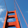
Best Trails of California
See our favorite hiking trails for each region of California.
See our favorite hiking trails for each region of California.
San Francisco Best Trails
For great hiking trails throughout the region, check these out.
For great hiking trails throughout the region, check these out.
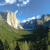
Yosemite's Best Trails
Epic scenery and adventures await. Summit hikes, waterfalls and more to choose from.
Epic scenery and adventures await. Summit hikes, waterfalls and more to choose from.