
Mist Trail, Vernal & Nevada Falls CA
• 5-star hike
• 3 to 6 mile options
• Moderate | Gain 1,040 to 2,020 ft | Peak 5,980 ft
• Yosemite, CA | Yosemite Region
.

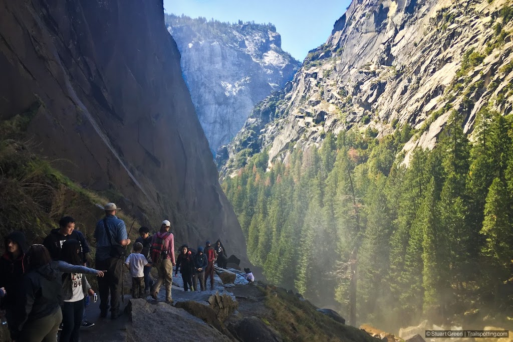
Vernal Falls closeup as viewed from the Mist Trail.
Vernal Falls and Nevada Falls are two of the most spectacular waterfalls in Yosemite Valley, but you won’t get to see them from the valley floor. This hike along the extremely popular John Muir trail and then Mist Trail will take you to either or both of the falls as you hike up the Merced River.
This hiking route follows the canyon cut out by the fast flowing river, past the towering Grizzly Peak and up many stone steps carved out of the rock by trail builders of the past. The views of Vernal Falls get better and better, until you’re finally climbing up sheer rock trails – thankfully protected by handrails – before reaching the top of the falls and the Emerald Pool. Here you can catch your breath and admire the views from the flat expanses of granite before heading back down. There are restrooms up here. Also, as inviting as it looks please do not disregard the signs and swim in the Emerald Pool – people have died getting swept up by the river and been taken over the falls.
| ⬤
5★ Vernal Falls
GPX File · AllTrails · Directions GPX? |
| ⬤
5★ Nevada Falls
GPX File · AllTrails · Directions |
| $ NPS entrance fee |
We mentioned that this trail is extremely popular. Not only is it the shortest route to these waterfalls, but it’s also the path to the summit of Half Dome. So expect crowds, and do your best to time your visit when you can. As the name suggests, the mist trail can also get very wet. Expect spray from Vernal Falls, and wear footwear which affords you some grip. This trail is also closed in months when icy weather makes the route treacherous.
Depending on your mode of transport and the availability of trailhead parking your trail length may vary. The formal trailhead is located by the Happy Isles Bridge that is reached via bus, but if you're arriving by car then you'll be starting in a parking lot that is located a further half-mile to the West. Our article describes the trail length depending on whether or not you're beginning at the Happy Isles Bridge and bus stop.
The Mist Trail is very popular at all times, except when it's closed in icy conditions.

Paved trail on the return to Happy Valley. | Vernal Falls in full.
Tangents:
• Official: Yosemite National Park
• AllTrails Public: Vernal & Nevada Falls
• Facebook Group: Comment, Follow Us

Trailspotting Nearby
5★ Half Dome (16 mi) ·
5★ Upper Yosemite Falls (7 mi) ·
4★ Lower Yosemite Falls (1 mi) ·
Show Map
Yosemite's Best Trails
Epic scenery and adventures await. Summit hikes, waterfalls and more to choose from.
Epic scenery and adventures await. Summit hikes, waterfalls and more to choose from.
Lake Tahoe's Best Trails
All-year-round fun at this Northern California landmark. Trailspotting has Lake Tahoe hikes for everyone.
All-year-round fun at this Northern California landmark. Trailspotting has Lake Tahoe hikes for everyone.


